
")
Natural Hazard and Risk Methodology


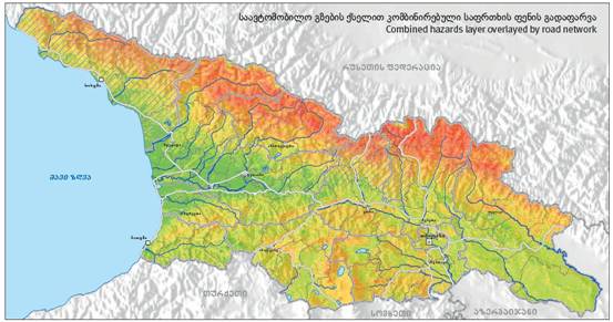
 There are three important components in risk analysis: 1) hazards; 2) vulnerability; and 3) elements-at-risk. They are characterized by both spatial and non-spatial attributes. Hazards are characterized by their temporal probability and intensity, derived from frequency-magnitude analysis. The hazard component in the equation actually refers to the probability of occurrence of a hazardous phenomenon within a specified period of time (a reference period). In the analysis we have taken into account 10 different hazard types: earthquakes, floods, landslides, mudflows, rockfall, snow avalanches, wildfire, drought, windstorm and hailstorm. For each of these hazard types a usceptibility maps was generated, classified into three classes (high, moderate and low). The historical information on past events was used to estimate the number of events that are likely to happen in a reference period of 50 years, and the size of individual events. The spatial probability was then calculated by dividing the area of the expected events by the total area of each hazard class.
Vulnerability and exposure was estimated for the following types of elements at risk: buildings, population, Gross domestic product (GDP), roads, forests, crops and natural protected areas. For each combination of hazard type and element at risk the overlapping areas were calculated with a GIS, resulting in the exposure information. Social, physical, environmental and economic vulnerability was expressed using a qualitative spatial mult-criteria evaluation technique. Vulnerability values were estimated for each combination of a hazard class (high, moderate and low) for each of the 10 hazard types and the elements at risk, and presented in a matrix. These were then used in the estimation of the final risk maps,
More on:
Hazard assessment
Exposure analysis
Vulnerability assessment
Risk Assessment
Hazard assessment
- Details
- Category: Background information
- Published on Sunday, 15 April 2012 07:51
- Written by Super User
- Hits: 28075
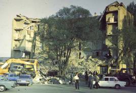 A hazard is defined as “a potentially damaging physical event, phenomenon or human activity that may cause the loss of life or injury, property damage, social and economic disruption or environmental degradation”. This event has a probability of occurrence within a specified period of time and within a given area, and has a given intensity. The aim of a hazard assessment is to identify the various types of hazards that may threaten a territory, and to partition the landscape in zones which are characterized by different expected intensities and frequencies of hazardous processes. In a hazard assessment several aspects should be evaluated: the triggering event, the areas where hazards are likely to initiate, the areas where the hazards are likely to spread, the expected intensity of the hazard and its associated frequency or probability of occurrence.
In this web-atlas we have analyzed a number of natural hazards that may occur in Georgia. The method for collecting historical information and for generating the hazard maps can consulting by following the links below.
Exposure analysis
- Details
- Category: Background information
- Published on Sunday, 15 April 2012 07:54
- Written by Super User
- Hits: 30876
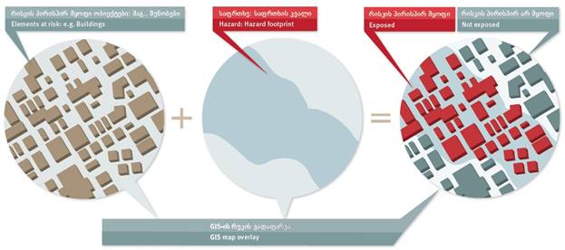
One of the most important components of the risk assessment is the exposure analysis. The interaction of elements at risk and hazard defines the exposure. We have seen the 10 hazard types for which hazard maps have been prepared: Earthquake (EQ), Flooding (FL), Landslides (LS), Mudlfows (MF), Rockfalls (RF), Wildfires (WF), Snow Avalanches (SA), Drought (DR), Windstorm (WS) and Hailstorm (HS).
The following exposure types are made:
- Buildings: Number of buildings per hazard class & hazard type within the administrative unit
- Population: Number of people per hazard class & hazard type within the administrative unit
- Gross Domestic Product in Lari per hazard class & hazard type within the administrative unit
- Roads: Length of roads (highways and paved roads) in meters per hazard class & hazard type within the administrative unit
- Pipelines: Length of pipelines (oilpipelines and gaspipelines) in meters per hazard class & hazard type within the administrative unit
- Protected Areas: Area of Natural Parks (protected areas) in hectares per hazard class & hazard type within the administrative unit
- Forests: Area of Forests in hectares per hazard class & hazard type within the administrative unit
- Crops: Area of Crops in hectares per hazard class & hazard type within the administrative unit
Vulnerability assessment
- Details
- Category: Background information
- Published on Sunday, 15 April 2012 07:56
- Written by Super User
- Hits: 29593
Vulnerability is the most complicated component of risk assessment, because the concept of vulnerability has a wide range of interpretations. Multiple definitions and different conceptual frameworks of vulnerability exist. Vulnerability refers to the conditions determined by physical, social, economic and environmental factors or processes, which increase the susceptibility of a community to the impact of hazards. It is the susceptibility to suffer damages or the intrinsic fragility of exposed elements, systems or communities that favours loss when affected by hazard events. It includes also the lack of resilience that influence the capacity to anticipate, cope with, resist, respond to, and recover from the impact of a physical event (www.move-fp7.eu/)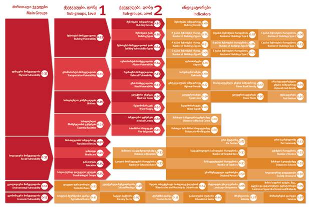
The vulnerability of communities and households can be analyzed in a holistic qualitative manner using a large number of criteria that characterize the physical, social, economic and environmental vulnerability. The importance of each of these indicators is evaluated by assigning weights and combining them using spatial multi-criteria evaluation. Physical vulnerability is evaluated as the interaction between the intensity of the hazard and the type of element-at-risk, making use of so-called vulnerability curves. Vulnerability is multi-dimensional (physical, social, economic, environmental, institutional, and human factors define vulnerability), dynamic (it changes over time), scale-dependent (it can be expressed at different scales from individuals to countries), and site-specific (each location might need its own approach).
In this project we have made use of so-called Spatial Multi-Criteria Evaluation for the analysis of vulnerability.
More information on the method used for vulnerability assessment.